The hail storms repeatedly pelting eastern South Africa over the past three weeks were the manifestation of three separate cutoff low pressure systems and the deepest low pressure over South Africa in years, says Wayne Venter, meteorologist at the South African Weather Service.
 Cutoff low pressure systems have been the cause of South Africa's greatest natural disasters.
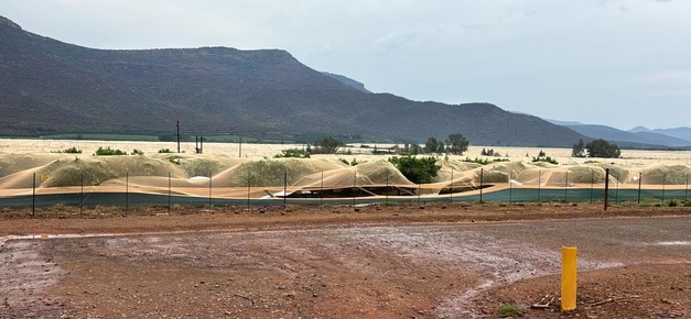
Right: "This used to be a bean field" (Ohrigstad, Limpopo)
In the upper reaches of the atmosphere a pocket of air gets trapped and cut off (hence the name 'cutoff low') from the jet stream that moves eastwards, causing strong wind disturbances which destabilise air flow to the south and east of the low pressure's core.
"And with temperatures being high and the moisture coming down from the tropical areas, conditions were favourable for the formation of hail," Venter explains. "The core of this cutoff layer together with the surface trough were very strong (deep). The air pressure wasn't this low in years."
The South African Weather Service had warned ahead of the approach of this unusually strong system and afterwards learned of hail storms and storm wind damage on three occasions (20, 22 and 26 October) near Groblersdal and Marble Hall, where the table grape harvest started last week.
On 23 October hail occurred over central and northern Limpopo, three days later over the Mpumalanga Lowveld and then finally on 27 and 28 October again over large areas of Limpopo and Mpumalanga.
Several people died as walls collapsed or metal sheets blew around. Motorists on the N4 highway near Belfast, Mpumalanga, experienced a white-out caused by one of the many hail storms over the past three weeks.
Watermelon, melon and butternut fields are destroyed in northern Limpopo, while to the east winter wheat due to be harvested two weeks from now, lie flattened. Entire fields of sugar bean seedlings planted just two weeks ago need to be replanted.
 Hail nets took one for the team: without them, a crop can be fully lost
Damage to soft citrus & navels
In the northern Drakensberg, along the border between Limpopo and Mpumalanga, many of South Africa's soft citrus and navel orchards have been established. Hail nets cover the majority of high-value soft citrus orchards, but erecting it is so expensive that many of the lower-earning navel orchards are uncovered.
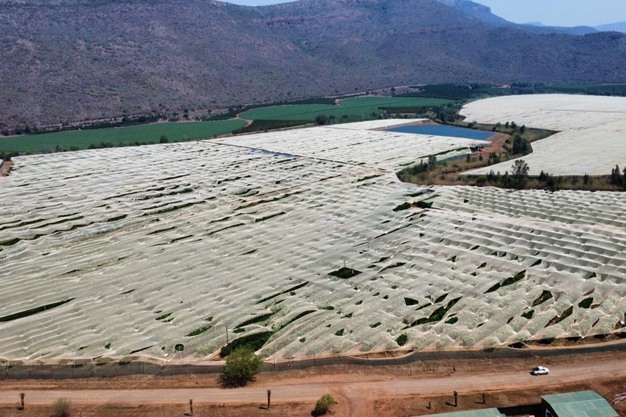
"We have 36 hectares of netting torn off and blown to the ground," says Smit le Roux of RuFrut in the Ohrigstad Valley. First the thumbnail-sized citrus fruit was hit by hail and then a few days later exceedingly strong winds ripped the hail nets apart.
"The tremendous wind during the second storm south of the Ohrigstad Valley further damaged the hail nets, snapping cables and pulling anchor poles from the ground."
He continues: "It is very difficult to quantify the impact. On our farm there are several million Rands' damage to our nets, and that's not considering the future crop loss and damage to trees."
Hail nets, even if torn to pieces, do still provide 80% to 90% of protection to the trees inside, and if it weren't for those nets, they could have lost the entire crop, so there's nothing for it but to replace thousands of square metres of nets.

Is 2024 a hail year?
It is a widely held belief that hail follows a cycle of seven years of little hail, broken by what is generally called "a hail year", and this year is another of those.
Lowveld farmers note uncharacteristically unstable weather over the past two months: excessive early spring heat followed by a cold about-turn. These conditions have not been conducive to flowering either.
Wayne Venter points out that meteorologists do not recognize a specific hail cycle, however, the possibility of hail is higher during Neutral and El Niño years "because the air is drier, warmer and therefore more unstable when moisture does become available through systems like cutoff low systems. This year has been an El Niño year and we have now switched over to the neutral phase. It looks like it could move to a weak La Nina phase soon which would mean more rainy conditions but not necessarily accompanied by high potential for hail."
Longterm data indicate that damaging hail over the summer rainfall area tends to occur during the transition seasons namely October, November and December, and then again during autumn.
Venter advises the public to always keep a watch for the weather service's thunder storm and hail advisories. Intense thunder storms and 'hail days' (days on which destructive hail and wind are likely) can occur anywhere over the interior and eastern coastline of South Africa, he says, with a concentration over the Mpumalanga and Gauteng Highveld, the eastern Free State, far south of Limpopo, western KwaZulu-Natal and the Eastern Cape interior.
![]()
For more information:
Wayne Venter
South African Weather Service
Tel: +27 12 367 6000
Email: [email protected]
https://www.weathersa.co.za/


